
Bantuan:VisualEditor/Peta
Halaman bantuan utama:
- saat ini: Bagaimana membuat peta dengan Kartographer di EditorVisual
- Mengenal Kartographer di tekswiki
- Kartographer - halaman bantuan lengkap
Menambahkan peta dengan VisualEditor
Memasukkan peta

Untuk menambahkan peta baru ke halaman, pilih "Sisipan" di menu perkakas VisualEditor. Kemudian tekan pranala "Lebih" untuk melihat pilihan Peta. Pilih "Peta". Peta akan ditambahkan ke posisi kursor Anda di halaman.

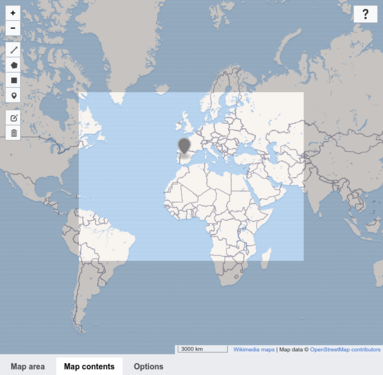
Menetapkan titik tengah peta, ukuran dan lingkup lokasi
Jendela dialog menampilkan peta interaktif dengan tiga tab di bawahnya: "Area peta" (dipilih secara baku), "Isi peta" dan "Pilih". Untuk menetapkan suatu lokasi, geser pusat dan sudut dari peta interaktif dan gunakan tombol "+" dan "-" di bawah peta untuk mengubah tingkat zum sampai peta interaktif menampilkan daerah yang inginkan. Anda juga bisa secara manual memasukkan lintang, bujur, tingkat zum, dan ukuran di isian di bawah peta.
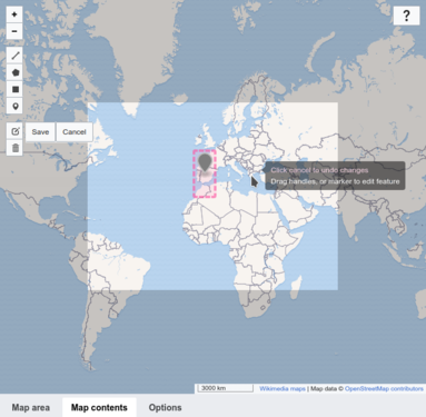
Menambah penanda dan bentuk shape
Untuk menambahkan bentuk dan penanda ke peta, klik tab "Konten peta" untuk menampilkan bilah alat. Anda dapat menambahkan garis, persegi panjang, poligon, dan penanda.
Setelah menambahkan elemen, gunakan ikon pensil-dan-kertas ![]() di toolbar peta untuk memodifikasinya.
Perhatikan bahwa menambahkan elemen ke peta secara otomatis menyatakan setiap elemen sebagai GeoJSON di kolom teks di bagian bawah jendela.
Anda juga dapat menempelkan GeoJSON yang valid ke dalam kolom teks.
Untuk menghapus elemen, pilih ikon tempat sampah diikuti dengan elemen yang ingin Anda hapus.
Kemudian klik "Simpan". Anda juga dapat menghapus elemen dari isian GeoJSON dibawah
di toolbar peta untuk memodifikasinya.
Perhatikan bahwa menambahkan elemen ke peta secara otomatis menyatakan setiap elemen sebagai GeoJSON di kolom teks di bagian bawah jendela.
Anda juga dapat menempelkan GeoJSON yang valid ke dalam kolom teks.
Untuk menghapus elemen, pilih ikon tempat sampah diikuti dengan elemen yang ingin Anda hapus.
Kemudian klik "Simpan". Anda juga dapat menghapus elemen dari isian GeoJSON dibawah
-
 Tab konten peta
 -
 Menambahkan penanda
 -
 Menyunting penanda


Pilihan pemformatan
Di tab "Pilihan", Anda dapat menambah sebuah judul (caption) peta. Anda dapat menentukan apakah akan menampilkan peta dengan atau tanpa bingkai dan bagaimana menyelaraskan peta di halaman. Anda juga dapat memilih bahasa untuk label peta. Harap di catat: Tidak semua label tersedia dalam setiap bahasa. (Informasi lebih lanjut di bahasa peta.)
Menyimpan peta
Ketika Anda sudah selesai, tekan "Sisipkan" (tombol di pojok atas jendela) untuk membuat peta Anda di halaman. Ini juga menutup dialog.

Menyunting peta yang ada
Untuk menyunting properti peta yang ada, pilih peta, lalu klik tombol "Edit" yang muncul.
Untuk mengubah ukuran peta yang ada, pilih peta di VisualEditor lalu pindahkan panah pengubah ukuran yang muncul di sudut bawah peta. Perhatikan bahwa ini hanya mengubah ukuran bingkai peta pada halaman, bukan tingkat pembesaran atau properti peta lainnya.
Untuk mengubah posisi peta di halaman, pilih peta lalu geser peta ke lokasi barunya.
Menghapus peta dengan VisualEditor
Untuk menghapus suatu peta, pilih peta tersebut dan, di papan ketik Anda, tekan kunci Delete atau kombinasi kunci CTRL-X. Anda juga dapat memilih "Potong" dari menu "Edit" peramban Anda.
Pengaturan peta lanjutan
Untuk pengaturan lanjutan terkait penyuntingan dan penandaan peta Kartographer, silakan lihat Bantuan:Ekstensi:Kartographer.