
Hilfe:VisualEditor/Karten
Haupthilfeseiten:
- aktuell: Wie man mit Kartographer im VisualEditor Karten erstellt
- Einführung zu Kartographer in Wikitext
- Kartographer - umfangreiche Hilfeseite
Karten mit dem VisualEditor hinzufügen
Eine Karte einfügen

Um eine neue Karte zur Seite hinzuzufügen, wähle in der Werkzeugleiste des VisualEditors „Einfügen“. Klicke auf „Mehr“, um das gesamte Menü anzuzeigen, und wähle dann „Karte“ aus. Dies wird eine Karte dort auf der Seite einfügen, wo sich der Cursor gerade befindet.

Einstellen des Kartenmittelpunkts, der Größe und der Proportionen
Das Dialogfenster zeigt eine interaktive Karte mit drei Registerkarten darunter: "Kartenbereich" (standardmäßig ausgewählt), "Karteninhalt" und "Optionen". Um einen Standort festzulegen, ziehe die Mitte und die Ecken der interaktiven Karte und verwende die Schaltflächen "+" und "-" am unteren Rand der Karte, um die Zoomstufe zu ändern, bis die interaktive Karte den gewünschten Bereich anzeigt. Du kannst auch den Breiten- und Längengrad, die Zoomstufe und die Größe manuell in die Felder unter der Karte eingeben.
Hinzufügen von Markern und Formen
Um der Karte Formen und Markierungen hinzuzufügen, klicke auf die Registerkarte "Karteninhalt", um eine Symbolleiste anzuzeigen. Du kannst Linien, Rechtecke, Polygone und Markierungen hinzufügen.
Nachdem du ein Element hinzugefügt hast, kannst du es mit dem Bleistift-und-Papier-Symbol ![]() in der Symbolleiste der Karte ändern.
Beachte, dass beim Hinzufügen von Elementen zur Karte jedes Element automatisch als GeoJSON in das Textfeld am unteren Rand des Fensters eingetragen wird.
Du kannst auch gültiges GeoJSON in das Textfeld eingeben.
Um ein Element zu entfernen, wähle das Mülleimer-Symbol, gefolgt von dem Element, das du löschen möchtest.
Klicke dann auf "Speichern". Du kannst das Element auch aus dem GeoJSON-Feld unten löschen.
in der Symbolleiste der Karte ändern.
Beachte, dass beim Hinzufügen von Elementen zur Karte jedes Element automatisch als GeoJSON in das Textfeld am unteren Rand des Fensters eingetragen wird.
Du kannst auch gültiges GeoJSON in das Textfeld eingeben.
Um ein Element zu entfernen, wähle das Mülleimer-Symbol, gefolgt von dem Element, das du löschen möchtest.
Klicke dann auf "Speichern". Du kannst das Element auch aus dem GeoJSON-Feld unten löschen.
-
 Tab "Karteninhalt"
 -
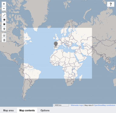 Hinzufügen einer Markierung
 -
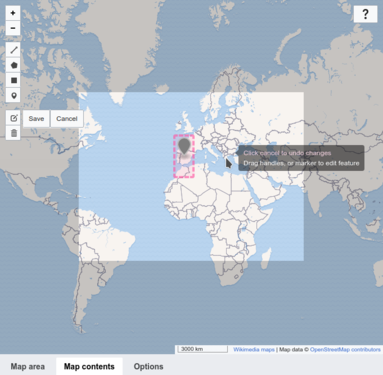 Bearbeiten einer Markierung


Formatierungsoptionen
Auf der Registerkarte „Optionen“ kannst du eine Beschriftung für die Karte hinzufügen. Du kannst festlegen, ob die Karte mit oder ohne Rahmen angezeigt werden soll und wie die Karte auf der Seite ausgerichtet werden soll. Du kannst auch eine Sprache für die Kartenbeschriftung auswählen. Beachte: Nicht alle Etiketten sind in jeder Sprache verfügbar. (Weitere Informationen zu den Kartensprachen.)
Speichern einer Karte
Wenn du fertig bist, klicke auf "Einfügen" (die Schaltfläche in der oberen Ecke des Fensters), um deine Karte auf der Seite zu erstellen. Damit wird der Dialog geschlossen.

Bearbeiten einer bestehenden Karte
Um die Eigenschaften einer bestehenden Karte zu bearbeiten, wähle die Karte aus und klicke dann auf die erscheinende Schaltfläche "Bearbeiten".
Um die Größe einer vorhandenen Karte zu ändern, wähle die Karte im VisualEditor aus und bewege dann die Pfeile zur Größenänderung, die in der unteren Ecke der Karte erscheinen. Beachte, dass dies nur die Größe des Kartenrahmens auf der Seite ändert, nicht aber die Zoomstufe oder eine andere Eigenschaft der Karte.
Um die Position einer Karte auf der Seite zu ändern, wähle die Karte aus und ziehe sie dann an ihre neue Position.
Entfernen von Karten mit dem VisualEditor
Um eine Karte zu entfernen, wähle sie aus und drücke auf deiner Tastatur die Entf-Taste oder die Tastenkombination STRG-X. Du kannst auch "Ausschneiden" aus dem Menü "Bearbeiten" deines Browsers wählen.
Erweiterte Karteneinstellungen
Für erweiterte Optionen zur Bearbeitung und Markierung von Kartographer-Karten siehe Hilfe:Erweiterung:Kartographer.