
راهنما:ویرایشگر دیداری/نقشه
صفحههای اصلی راهنما:
- در حال حاضر: چگونگی استفاده از Kartographer در ویرایشگر دیداری
- مقدمه ای بر Kartographer در ویکیمتن
- چگونگی استفاده از Kartographer - صفحهٔ راهنمای گسترده
افزودن نقشهها با ویرایشگر دیداری
افزودن یک نقشه

برای افزودن نقشهای جدید به صفحه، از منوی ابزار ویرایشگر دیداری «درج» را انتخاب کنید. سپس روی «بیشتر» کلیک کنید تا گزینهٔ نقشه را ببینید. «نقشه» را انتخاب کنید. نقشه در جایی که نشانگر قرار دارد، درج خواهد شد. Click "More" to show the entire menu, then select "Map". This will add a map at the current location of your cursor on the page.

Setting map center point, size and proportions
The dialog window displays an interactive map with three tabs below it: "Map area" (selected by default), "Map contents" and "Options". با فشردن آیکون «نقشه» پنجرهای باز میشود که نقشهای تعاملی را نمایش میدهد. برای تنظیم یک مکان، نقشه تعاملی را بکشید و برای بزرگنمایی از دکمههای «+» و «-» استفاده کنید تا هنگامی که آنچه دنبالش هستید را ببینید. You can also manually enter latitude, longitude, zoom level and size in the fields below the map.
Adding markers and shapes
To add shapes and markers to the map, click the "Map contents" tab to display a toolbar. You can add lines, rectangles, polygons and markers.
After adding an element, use the pencil-and-paper icon ![]() in the map toolbar to modify it.
Note that adding elements to the map automatically expresses each element as GeoJSON in the text field at the bottom of the window.
You can also paste valid GeoJSON into the text field.
To remove an element, select the trash can icon followed by the element you wish to delete.
Then click "Save". You can also delete the element from the GeoJSON field below.
in the map toolbar to modify it.
Note that adding elements to the map automatically expresses each element as GeoJSON in the text field at the bottom of the window.
You can also paste valid GeoJSON into the text field.
To remove an element, select the trash can icon followed by the element you wish to delete.
Then click "Save". You can also delete the element from the GeoJSON field below.
-
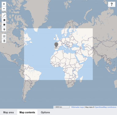
 Map contents tab
 -
 Adding a marker
 -
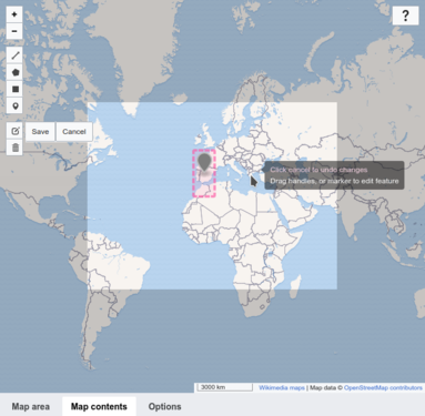 Editing a marker


Formatting options
میتوانید اندازه، تراز و زبان برچسبهای نقشه را انتخاب کنید. به یاد داشته باشید که همهٔ برچسبها در هر زبان در دسترس نیستند. (اطلاعات بیشتر دربارهٔ زبانهای نقشه) You can define whether to show the map with or without a frame and how to align the map on the page. You can also select a language for map labels. Note: Not all labels are available in every language. (More information on map languages.)
Saving a map
پس از پایان کار، دکمهٔ «درج» را فشار دهید تا پنجره بسته شود و نقشهٔ شما به صفحه افزوده شود.

Editing an existing map
To edit an existing map's properties, select the map and then click the "Edit" button that appears.
To resize an existing map, select the map in the VisualEditor and then move the resizing arrows that appear on the bottom corner of the map. Note that this only changes the size of the map's frame on the page, not the zoom level nor any other of the map's properties.
To change a map's position on the page, select the map and then drag the map to its new location.
حدف نقشه با ویرایشگر دیداری
برای حذف نقشه، آن را انتخاب کنید و دکمهٔ delete روی صفحه کلید را فشار دهید. همچنین میتوانید از فرمان «برش» در منوی «ویرایش» مرورگر خود استفاده کنید.
تنظیمات پیشرفته نقشه
برای تنظیمات پیشرفتهٔ نقشه، مانند علامتها، شکلهای دلخواه و سایر تنظیمات GeoJSON راهنما:افزونه:Kartographer را ببینید.